Kaho’olawe

Pohaku, Kaho\'olawe

Kaho‘olawe is the smallest of the 8 main islands in Hawai‘i and is named in honor of Kanaloa, Hawaiian deity of the ocean. The island is also historically referred to as Kohemalamalama O Kanaloa. After the Japanese attack on Pearl Harbor, the U.S. Army declared martial law throughout Hawai‘i and took control of Kaho‘olawe. The island was used as a bombing range, and in 1953 title to the island was given to the U.S. Navy. The use of bunker busters during this time cracked the water table of the island, and the freshwater aquifer of the island spilled into the ocean.

In the mid-seventies, members of Protect Kaho‘olawe ‘Ohana (PKO) began a series of occupations of the island in an effort to halt the bombing. The PKO also filed suit in Federal District Court to enjoin the Navy’s bombing activities. In 1977, the Federal District Court ordered a partial summary judgment requiring the Navy to conduct an environmental impact statement and supply an inventory of, and protect, the historic sites on the island.

As a result of PKO actions and litigation, President George Bush Sr. ordered a stop to the bombing of Kaho‘olawe in 1990. The Navy officially halted bombing practices in 1993, and contracted the removal of unexploded ordnance—a $400 million promise of clean-up. Yet, by November 2003, 74% of the island’s surface was cleared. Only nine percent of the island’s surface has been cleared to a depth of four feet. Ten percent of the island, or 2,936 acres, has not been cleared and is unsafe to access.
Transfer of access control was returned to the State of Hawai‘i in a ceremony at ‘Iolani Palace on November 11, 2003.

Photograph by Jan Becket. Editor of a book of photographs depicting 60 heiau on the island of Oahu.

Halawa Valley

H3 Protest

The stand against H3 was particularly important in amplifying female voices in the Hawaiian movement. It is today viewed by some as an important intersect between women’s empowerment and the Hawaiian movement.

Construction for H3 began in the 1980s amidst enormous community protest. An unprecedented action by U.S. Senator Daniel Inouye exempted the highway from virtually all environmental laws—a “rider” on a Department of Defense budget bill. The highway finally opened in 1997, This highway runs through the birthplace of Papa, the ancestral goddess of the Hawaiian people, in Halawa Valley.

Today, Native Hawaiian cultural practitioners continue to stand and call for its removal. In local lore, the freeway is considered “cursed”, with harms visiting even those who traverse it. Ongoing environmental concerns include weed encroachment, light pollution, asbestos pollution, water and stream ecosystem problems, along with a host of other concerns.

Asbestos dust from the brake linings of traversing vehicles collects on the road in fairly large quantities. During strong winds, the dust becomes airborne, posing serious health risks to those working beneath the freeway pillars, many of whom are indigenous taro farmers and other cultural practitioners.

Light pollution from the highway continues to threaten the endangered pueo (endemic Hawaiian owl), and other native birds. The Oahu ‘Alauahio, a small finch-like bird, was likely made extinct by H-3. Their have been no sightings of this bird since H3 construction; it’s last known home was Halawa.

Photo by Ed Greevy.

Chinatown Evictions

“The city didn’t do anything in Chinatown without being forced to do it. They had no plans at all for low-income housing,” – Mari McCaig, co-coordinator of PACE (People Against Chinatown Evictions).

Chinatown Evictions - Honolulu
PACE was formed in the 1970s, initially to fight for the right of those residents being displaced on River Street by the city redevelopment plans to come home—to secure housing in the same location.

PACE organized large demonstrations—including an occupation of Honolulu Hale. Its members were arrested, court fights ensued. Ultimately, residents secured an agreement that guaranteed them units in the new housing projects. Today, the units remain designated low-income.

Photo by Ed Greevy.

‘Ilio’ulaokalani Coalition

Painting of \'Ilio\'ulaokalani Gathering at State Capitol

The ‘Ilio’ulaokalani Coalition found its beginning in 1997, when native Hawaiian cultural practitioners — kumu hula and their halau members — held a 24-hour vigil at the State Capitol. They were protesting Senate Bill 8 and House Bill 1920, which would have required native Hawaiians to register to practice traditional religious, cultural and subsistence practices on undeveloped land—a move towards criminalizing indigenous practice. The bill was proposed on the heels of the seminal State Supreme Court ruling Property Access Shoreline Hawaii (PASH) vs. Hawaii County Planning Commission, which held that the state must protect all customary and traditional native Hawaiian rights exercised for cultural, religious and subsistence purposes. The protest around SB8 was one that mobilized haumana and one of the first to articulate a political viewpoint from the perspective of indigenous cultural practice. It marked a key shift in the modern hula—from hula as entertainment to hula as a political act.

This is a reproduction by the artist, Daniela Minerbi, of an original 4-foot painting of the ‘Ilio’ulaokalani protest. The original now resides in Italy.

George Santos

george santos, photograph by ed greevy

The struggle against residential development of Kalama Valley by its landowner, Bishop Estate, is generally considered one of the pivotal actions beginning of the Hawaiian movement. George Santos and his fight to keep his pig farm helped launch two decades of activism to preserve the rights, environment, and way of life of local people against the profit interests of the state, large landowners, and foreign and mainland corporations.

Ed Greevy is an independent photographer in Hawai’i. Greevy began his documentation of land rights movement the 1971 with Save Our Surf because the various State/private interests plans to destroy surf/reef sites made no sense to him. This led to participation in other land rights struggles throughout the island of Oahu: Kalama Valley, Ota Camp, Chinatown, Waiahole/Waikane, Niumalu/Nawiliwili on Kaua’i, Coconut Grove, Waimanalo, Ewa, Sand Island, Mokauea Island, Heeia/Heeia Kea, and Kahana Valley.

Greevy’s contribution to resistance is through his long-term commitment in photographically documenting each struggle and making his work available to others who were/are resisting destructive development.

Makua: Two Panels

Peace and Justice are foundations that have been laid by others before we arrived upon the scene. Any efforts on my part are predicated upon this fact. Legacy is just that – peace is just that, a legacy of compassion and standing for one another, bearing witness, and standing in solidarity. The pieces represented here have been exhibited in other venues, yet the message of this particular work is the same. Strive for justice, seek the truth and speak to the heart of power, make a difference as you can be counted. Love your land, she is our mother, love one another, we are of one blood. – Meleanna.

Two Panels. Meleanna Meyer, 2007.

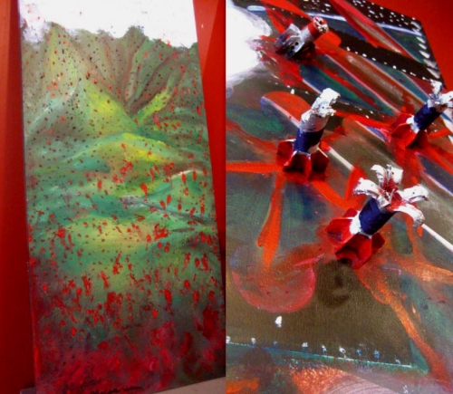
Makua: Two Panels. Meleanna Meyer, 2007

On the Waianae Coast of Oahu, lies Makua Valley. Pre-contact, the valley—called “parent” in Hawaiian—was among of the most productive agricultural lands on the island. An ancient trail at the back of the valley went over the mountains into Waialua, connecting Makua to all parts of the island.

Of Makua’s Kamuakuopio Heiau, very little is left today. What remains is a raised sand platform, 120 ft. by 100ft., and two piles of large stones. Stones from the heiau were stolen in modern times to build rock fences. The Makua koa (fishing shrine), also in ruins, is said to lie in the middle of the beach. The Makua koa remains a much respected and honored spot to Hawaiian fisherman today.

After the Japanese attack on Pearl Harbor, the Army confiscated 6,600 acres in and around the valley to train troops for World War II, evicting the residents who lived there. The once-vibrant history, culture, environment and community were largely destroyed, as Makua was used as a bombing practice area by the U.S. military.

Yet, communities in Makua Valley today continue in their efforts to perpetuate their unique culture, protect their fragile natural environment, and resist the abuse of their land. Community resistance and protest ultimately halted bombing of the area in 1998.

Nonetheless, the military has continued to push to resume bombing practice in Makua Valley. Since 2003, live fire exercises have been prevented by court order. The valley is still home to many remaining sites and many native plants and animals in the 4,190-acre valley are still endangered.

The second panel in this pair of works displays ordnance collected from Makua Valley.

Born and raised, Ms. Meyer comes from Mokapu, O’ahu, and is the second child of Harry and Emma Meyer. She has had a lifelong love for the arts in all forms. She received her B.A.in design and photography from Stanford University. Meleanna was mentored by Nathan Oliveira and Leo Holub. Her kumu in mana’o Hawai’i is respected educator, Keola Lake. Meleanna received her MA in Educational Foundations from the University of Hawai’i at Manoa under the mentorship of Dr. Royal Fruehling. An East West Center grantee, APAWLI and Salzberg Fellow, she has been able to lend her many talents to a wide range of arts and culture collaborations. Ms. Meyer is a practicing artist, educator and filmmaker, and has taught in a wide range of educational settings both public and private, at the University level, in the charter schools, as an artist in residence and currently, contractually also as a consultant with Kamehameha schools Literacy and Instruction program as a arts/culture curriculum specialist. As a filmmaker she has three documentaries to her credit, is a published author and illustrator. Having received numerous awards for her visual art, her work also hangs in the State Museum, in the Honolulu City & County collection, with works in private collections both here and abroad.